
Scenery & Backdrops 090116 07Capture Date: Sep 1, 2016 12:43 PM•Views: 236No comments yet. All fields are required, fill in the form. Comment successfully added. Comment
|
24 Progress Signals 060316 01
Beginning a look at the photo backdrops done by Kelly Daniels, a local artist. He downloaded period (ca 1957) photos and spliced them together with high plains sky and clouds and the prairie to match the locations on the model. He worked about a year on it. We provided the Masonite substrate and taped and seamed it to give a smooth surface for him to glue his photoshopped pictures which he printed on vinyl. Then he hand touched up most of the seams between vinyl sections.
This is the Indian Village in west Cheyenne and on out into the high plains prairie. The elevation of Cheyenne is 6,000 at milepost http:// (501 miles from Council Bluffs, the start of the Intercontinental RR.
Capture Date: Jun 3, 2016 12:42 PM•Views: 347
No comments yet. All fields are required, fill in the form. Comment successfully added. Comment
|
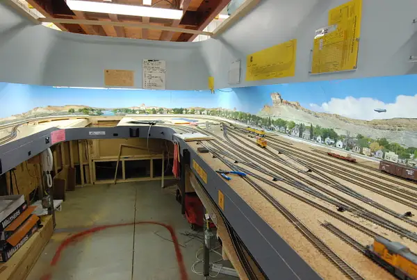
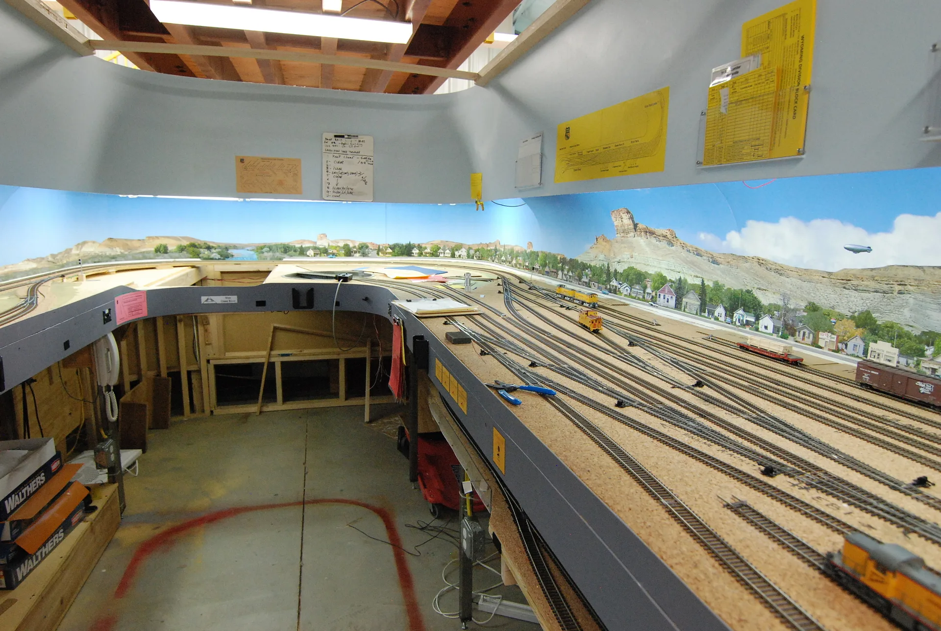
24 Progress Signals 060316 02
This is a view starting up Sherman Hill westbound from Cheyenne. The two big posts with the backdrops wrapped around them are 1/3 of the way (25 feet) from either end of the building. The wiring above the backdrop is a Wilson cell phone antenna repeater/amplifier so we get good cell coverage inside the steel building. This view shows tracks #1 and #2 (west and east bound) running along the photo backdrop. Under the emergency lights is the UP Granite quarry and tailing dump. Track #3, the Harriman Cutoff and its siding is shown. It is an alternate route that is 19 miles longer to Dale than the 35 mile Track #1 route, and it cut off 50 feet of elevation change over its 54 mile length. These (mostly the added 19 miles) cut the constant grade up the Hill from 1.55 to 1.15%. #3 is also used as a direct E and W route to and from Denver to Ogden, bypassing Cheyenne by the Speer Wye. With respect to Denver it is often called the Borie Cutoff.
Capture Date: Jun 3, 2016 12:42 PM•Views: 336
No comments yet. All fields are required, fill in the form. Comment successfully added. Comment
|
24 Progress Signals 060316 03
Just beyond the Granite Quarry the iconic rounder boulder, pink granite rock out croppings of Sherman Hill start. The model maximum elevation is right at this second building beam. Note the huge roof beams necessary to adequately support the mezzanine which is only supported from the two beams and the ends at the building walls. The yellow stairs for the west end of the mezzanine are shown. The junction of tracks #1, 2, and 3 is Dale Junction. We change the current of running from right hand to left here, left hand running down (and up) from Laramie. Up runs left hand up the west side of the Hill to take advantage of the newer 1905 Track #2 grade as compared to the original 1860's #1. The west twin portals of the Hermosa tunnels (Tunnel #1--numbered as one tunnel) can be seen. The mountain through which the tunnels are cut looks hardly worth it in height in real life--it must be very hard rock to warrant two tunnels. Laramie is 10-15 feet to the bottom left of the tracks.
Capture Date: Jun 3, 2016 12:43 PM•Views: 339
No comments yet. All fields are required, fill in the form. Comment successfully added. Comment
|
Scenery & Backdrops 090116 08
A little further along with Sherman and Dale Junction. This show is taken looking west along Track #3 (Harriman Cutoff) from Harriman, Wyo and the coal tower there toward Dale Junction in the distance. There are two of the iconic Sherman Hill "hillocks" that Allen made out of laid up foam board. Track s 1 and 2 can be seen next to the backdrop. The valley visible as the dip in the fascia at the very corner of the aisle is the Dale Creek valley. Dale Creek was just a trickle, but a huge bridge was needed to span the gap. There were 2 or 3 bridges, and the last was finally replaced with Dale Fill, famous because of its huge size.
Capture Date: Sep 1, 2016 12:43 PM•Views: 215
No comments yet. All fields are required, fill in the form. Comment successfully added. Comment
|
Scenery & Backdrops 090116 09
Close up of Dale. The tortoise machines hanging under the roadbed (plywood here instead of spline for ease of mounting the Tortoise machines) are controlled by rocker switches mounted behind the yellow panel to the left. Each switch is mounted in a slit in the wall of a piece of PVC pipe glued perpendicular to the back of the panel. The holes are 1 inch diameter and a finger can be stuck inside it to rock the switch forward or back. A track plan of the Dale area is shown on the panel face and the routes, through or diverging, are shown by green LED's on the red "tracks."
The back of Ideal cement plant is seen from the rear of the lower level bench end cap. This is aisle is left open for access to the lower level tracks because of the width of the end cap.
Capture Date: Sep 1, 2016 12:44 PM•Views: 216
No comments yet. All fields are required, fill in the form. Comment successfully added. Comment
|
Panel and Tortoise Count
A table of the 16 panels and number of turnout Tortoise switch machines operated from each. Some turnouts are synchronized in pairs, so the number of electrical switches is less than the number of turnouts.
Upload Date: Sep 2, 2016 01:03 PM•Views: 218
No comments yet. All fields are required, fill in the form. Comment successfully added. Comment
|
Dale Creek Tresle
The original wooden trestle over Dale Creek. It was 450 feet long and stood 150 feet over the trickle of the stream. What a bridge for a creek that could be stepped over without jumping! This bridge burned and was replaced by at least one steel bridge, and finally by Dale Fill of dirt.
Upload Date: Sep 2, 2016 12:23 PM•Views: 217
No comments yet. All fields are required, fill in the form. Comment successfully added. Comment
|
Scenery & Backdrops 090116 10
The seven turnouts of Dale Junction where Track 3 joins Track 1 and 2. This is where we change the current of running for operations from right hand running up from Cheyenne (to the left under the backdrop) to left hand running down to Laramie and through the Hermosa twin tunnels, numbered together as #1.
Allen made a great video of a three way meet at Dale. See YouTube at https://http://
Capture Date: Sep 1, 2016 12:46 PM•Views: 219
No comments yet. All fields are required, fill in the form. Comment successfully added. Comment
|
24 Progress Signals 060316 04
Here is Laramie with the view reversed from Hermosa behind the camera. We use Baagdon Enterprises Geodesic Foam hard shell over foam insulation and cardboard strips for support, and it is all held together by hot glue. We have gone to the ore expensive purple foam, 1" thick, because the hot glue does not melt it. We have no ballast yet. The texture visible is the 1/4" thick cork flooring underlayment material that comes in 48" wide rolls x 50 feet. We cut it on an angle with a carpet knife along a fence on a vacuum hold down box I made for a big shop vac. The cork roadbed as "ballast" fits the UP standard 24" x 13 foot width for a single track. Just visible are the edges of the outer spline of the spline roadbed which we glued in place with the curves bent as we glued along. The storage silos of Monolith Redi Mix plant of Laramie is at the end of the bench just before the Laramie Tie Treating Plant.
Capture Date: Jun 3, 2016 12:44 PM•Views: 347
No comments yet. All fields are required, fill in the form. Comment successfully added. Comment
|
24 Progress Signals 060316 14
This is an overall view of the last few photos with Laramie in the foreground. The clipboard, with an 8 1/2 x 11 Train order, a 1/2 sheet card stock block card, and a 1/4 sheet car card and pencil on it, is not to http:// ice dock (2/5 of the 15 foot planned dock in placed in 2 sections) is at the far end. This shows the widened and modified Laramie to allow two full trains to ice at once and the reduced stock yard track (extreme left spur). This upper level of the mushroom design is reached by operators standing on a plywood riser 17" above the concrete floor. The lower level just peeking up from between the benches behind the coal tower is worked from the concrete. Notice a hidden advantage to the mushroom design--neither level can see the other level, neither tracks nor operators.
Capture Date: Jun 3, 2016 01:04 PM•Views: 359
No comments yet. All fields are required, fill in the form. Comment successfully added. Comment
Fred Grootuis Aug 20, 2016 12:29 PM
Read comment →
Very cool! I am really looking forward to seeing the progress first hand that you have made since last I visited. |
24 Progress Signals 060316 05
A train level view of Laramie. The arch at the end of the aisle is an escape hole for personnel to crawl through in case a fire behind them blocks exiting to the ramp up onto the upper level riser. The ramp is 2 aisles to the left. There is a single ttrack on the arch, which is the beginning of the OSL (Oregon Short Line) that emerges from a mouse hole on the left and bends around on a large radius curve under the lower level (i.e., on a 3rd level) to run as hidden track under the third level to a separate staging yard representing Portland.
Capture Date: Jun 3, 2016 12:45 PM•Views: 342
No comments yet. All fields are required, fill in the form. Comment successfully added. Comment
|
24 Progress Signals 060316 08
More of the Laramie backdrop. The view is east down the streets of Laramie. (The E-W tracks run due north through Laramie). Note that only two of the required 5+ sections of ice docks are built. When finished it will be 17 feet long to handle an entire 30 PFE car train on each side.
Capture Date: Jun 3, 2016 12:54 PM•Views: 349
No comments yet. All fields are required, fill in the form. Comment successfully added. Comment
|
24 Progress Signals 060316 09
Leaving Laramie, we go across the end cap and the Rock River. Around the end cap is the Team Track and the stock yard at Medicine Bow, which is a prime ranching area. The old Highway 2 lane US 30 is shown as the Masonite curving strip between the tracks and the backdrop. The crossover at the very left of the photo is for freight trains to pass passenger trains that may be stopped in front of the depot, just out of the photo. Normally, only hot shot PFE Specials or perhaps a Forwarder (our name for through trains that only stop for fuel, water, sand and ash dumping, and loco changes) would pass a passenger train.
Capture Date: Jun 3, 2016 12:54 PM•Views: 330
No comments yet. All fields are required, fill in the form. Comment successfully added. Comment
|
24 Progress Signals 060316 07
(Referring to the previous photo): At the Laramie west yard limits are signal masts, each with a 3 aspect (R, Y, G) head. The west bound (silver back) signal across the tracks from the black face of the east bound signal, is an ABS--green if the next two blocks are unoccupied, yellow if the second block ahead is occupied, and red it the first block ahead is occupied. This is the normal characteristics (the reds are permissive reds--trains can proceed slow with the ability to stop for any blockage, bad turnout, and so on.)
Just past Medicine Bow and the Medicine Bow River, more prairie and the town. The wide space is for the Virginian, a Victorian style white 4 floor hotel which was where Owen Wooster lived while he wrote the world's first full length western novel, "The Virginian." "Smile, when you call me that."
Capture Date: Jun 3, 2016 12:49 PM•Views: 331
No comments yet. All fields are required, fill in the form. Comment successfully added. Comment
|


No comments yet...
All fields are required, fill in the form.
Comment successfully added.
Comment