")
4 Skagway&YukonRouteRR (11 aS)
World's only single tower suspension bridge. This is the road we just passed over.
Capture Date: Aug 6, 2017 10:10 AM•Views: 44
No comments yet. All fields are required, fill in the form. Comment successfully added. Comment
|
4 Skagway&YukonRouteRR (12color BC aS)
World's only single tower suspension bridge. This is the road we just passed over. The route of the road, and the train, and not incidentally, the 1898 gold rush train from Skagway to the Yukon. This was one of two routes by foot. The other was up the Chilkoot Pass. Canada required one ton of supplies to enter from Alaska, so it took many trips by foot. According to Wikipedia: Those who landed at Skagway made their way over the White Pass before cutting across to Bennett Lake. Although the trail began gently, it progressed over several mountains with paths as narrow as 2 fee and in wider parts covered with boulders and sharp rocks. Under these conditions horses died in huge numbers, giving the route the informal name of Dead Horse Trail. The volumes of travelers and the wet weather made the trail impassable and, by late 1897, it was closed until further notice, leaving around 5,000 stranded in Skagway.
An alternative toll road suitable for wagons was eventually constructed (con't next photo)
Capture Date: Aug 6, 2017 10:10 AM•Views: 53
No comments yet. All fields are required, fill in the form. Comment successfully added. Comment
|
4 Skagway&YukonRouteRR (23 SGB)
(con't from last page) ...and, by late 1897, it was closed until further notice, leaving around 5,000 stranded in Skagway. An alternative toll road suitable for wagons was eventually constructed and this, combined with colder weather that froze the muddy ground, allowed the White Pass to reopen, and prospectors began to make their way into Canada. Moving supplies and equipment over the pass had to be done in stages. Most divided their belongings into 65 pounds (29 kg) packages that could be carried on a man's back, or heavier loads that could be pulled by hand on a sled. Ferrying packages forwards and walking back for more, a prospector would need about thirty round trips, a distance of at least 2,500 miles (4,000 km), before they had moved all of their supplies to the end of the trail. Even using a heavy sled, a strong man would be covering 1,000 miles (1,600 km) and need around 90 days to reach Lake Bennett.
Capture Date: Aug 6, 2017 10:26 AM•Views: 41
No comments yet. All fields are required, fill in the form. Comment successfully added. Comment
|
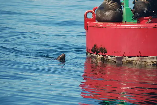
4 Skagway&YukonRouteRR (27 SGB)
This photo and the last one shows a black bear and her 2 cubs foraging. All three can be seen in the previous photo (The second cub only shows its black face looking directly at the camera and about 1/3 of the way from the left hand cub to the mama bear.
Why do I say it was a black bear? See next image.
Capture Date: Aug 6, 2017 10:27 AM•Views: 41
No comments yet. All fields are required, fill in the form. Comment successfully added. Comment
|
4 Black vs Brown(Grizzly) bears
Black vs Brown(Grizzly) bears
Upload Date: Oct 29, 2017 12:52 PM•Views: 480
No comments yet. All fields are required, fill in the form. Comment successfully added. Comment
|
4 Skagway&YukonRouteRR (34)
We had assigned seats in an assigned car on the train. We were in the next to last car. We boarded at Fraser, B. C.,Canada, about 2/3 of the way from Skagway to Lake Bennett, B. C. (See map ahead)
The coaches were real ones preserved from 1898!!
Capture Date: Aug 6, 2017 10:53 AM•Views: 44
No comments yet. All fields are required, fill in the form. Comment successfully added. Comment
|
WP&YRRR
Our train ride was from Fraser, British Columbia back down to Skagway, a distance of 27.7 miles on the railroad. The 20.4 miles to the Summit climb is almost 3,000 feet, with steep grades of almost 3.9%. Because of the tight curves it was narrow gauge, and was built to suplant the Chilkoot route and the foot path White Pass routes to the gold fields in the Yukon, which was about 550 miles by build it yourself boat from Lake Bennett. Note we went into British Columbia, Canada.
Capture Date: Sep 1, 2017 08:30 AM•Views: 41
No comments yet. All fields are required, fill in the form. Comment successfully added. Comment
|
4 Skagway&YukonRouteRR (35)
This is probably Bernard Lake at Summit, BC, Canada
Capture Date: Aug 6, 2017 10:58 AM•Views: 60
No comments yet. All fields are required, fill in the form. Comment successfully added. Comment
|
4 Skagway&YukonRouteRR (42)
This may be Summit Lake at the summit of White Pass.
Capture Date: Aug 6, 2017 11:10 AM•Views: 39
No comments yet. All fields are required, fill in the form. Comment successfully added. Comment
|
4 Skagway&YukonRouteRR (43)
There are numerous ponds near the summit like this that never dry up, because of no channel to drain them. Consequently they have no fish, because in the winter they freeze over shutting out the water's absorption of oxygen.
Capture Date: Aug 6, 2017 11:13 AM•Views: 43
No comments yet. All fields are required, fill in the form. Comment successfully added. Comment
|
4 Skagway&YukonRouteRR (46)
Even on level ground the foot path and the railroad had to contend with boulder strewn open spaces. Pack horses were used, but about 3,000 died due to the harshness of the train and the inexperience of the men driving them. Note the rounded character of the rocks due to glaciers sliding over them.
Capture Date: Aug 6, 2017 11:16 AM•Views: 44
No comments yet. All fields are required, fill in the form. Comment successfully added. Comment
|
4 Skagway&YukonRouteRR (57)
The US-B. C. boundary at White Pass Summit, 2,885 ft. Here the Royal Canadian Mounted Police stopped gold stampeders if they did not have the required 1 ton of supplies to enter Canada.
Capture Date: Aug 6, 2017 11:30 AM•Views: 41
No comments yet. All fields are required, fill in the form. Comment successfully added. Comment
|
4 Skagway&YukonRouteRR (58)
A good example of why the RR was constructed, so that the prospectors could ship their one ton of supplies required by Canada, rather than taking 30 or so trips by foot. Beautiful country, but rugged.
Capture Date: Aug 6, 2017 11:33 AM•Views: 40
No comments yet. All fields are required, fill in the form. Comment successfully added. Comment
|
4 Skagway&YukonRouteRR (59)
Trail of '98 (1898).
Capture Date: Aug 6, 2017 11:34 AM•Views: 39
No comments yet. All fields are required, fill in the form. Comment successfully added. Comment
|
4 Skagway&YukonRouteRR (60)
Trail of '98 (1898). Imagine carrying 50 or 70 pounds of supplies over such a trail 30 or more times. And who guarded your supplies at the top end? The Mounties?
Capture Date: Aug 6, 2017 11:34 AM•Views: 38
No comments yet. All fields are required, fill in the form. Comment successfully added. Comment
|


No comments yet...
All fields are required, fill in the form.
Comment successfully added.
Comment